Layers of Time: Tracing Collective Memory and Cultural Identity in Karachi’s Historic Urban Landscape
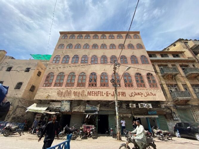
Walking through the unwinding streets of Old Town in Karachi, one may construct a list of questions when seeing the unique characteristics of a neighborhood not so common in modern day Karachi. Unlike the broader, regular streets of the colonial part of Karachi, with staggering architecture standing proudly on the major roads and streets, the Old Town appears to be humble and close-knit, as if built for a community and by a community.
Although much is changing about this part of the city, what remains intact is the people’s association with the place, where every building has a story and so does every street. Unique building appearances, features, architectural elements, and street patterns are all reminiscent of the people who built them. One can easily navigate and make connections to the characteristics of the original dwellers of the place, and its changing character speaks to the current affairs of the city and the country. This part of the city also speaks to the cultural plurality that was prevalent pre-independence and lasted for a few more years post-independence (i.e. after 1947).
Although the original inhabitants were largely replaced by new settlers, what remains are the footprints of the ones who have gone. From inscriptions on the buildings to building elements and architectural features, street patterns, religious spaces, and the vernacular spoken on the streets, everything gives an idea of the transition from the past to present with an ideation of what the future holds for this area.
These elements altogether form a collective memory and identity, both of which play pivotal roles in shaping the dynamics of urban spaces and serve as the threads that weave together the intricate fabric of communities within cities (Assmann, 2011; Nora, 1989). Memory, as Lynch (1960) stated, is manifested in many forms, such as from inscriptions etched on historical landmarks or the vernacular spoken on the streets, which form a rich tapestry of daily urban life and give a sense of belonging and continuity.
To study the relationships between urban space and people’s identity, memory, and day-to-day interactions besides politics and history, scholars have developed theoretical frameworks alongside a variety of methodologies. Ethnographic approaches, such as participant observation and interviews, have been instrumental in capturing the lived experiences of residents within urban neighborhoods (Ahmed, 2014). Similarly, archival research and textual analysis have been used to trace the historical trajectories of cities and uncover hidden layers of memory embedded within their built environments (Khan, 2010).
Weaving Urban Space, Memory, Culture, and Identity Together
In a broader sense, this research connects how urban space is woven together with people’s identity and memory, i.e. their ways of living, ideologies and personalities, adopting a multidimensional approach. Urban space refers not only to physical environments but also to the social, cultural, and symbolic meanings attributed to them (Lynch, 1960). It encompasses the built environment as well as the social interactions and practices that occur within it, shaping the experiences and identities of urban residents.
Collective memory, drawing upon the work of Assmann (2011) and Nora (1989), refers to the shared reservoir of past experiences and cultural narratives that bind communities together. It is concerned with both individual and collective recollections of the past, which shape how people perceive and relate to their surroundings within urban contexts.
Culture encompasses the beliefs, values, customs, and practices that characterize a particular community or society (Appadurai, 1996), covering both tangible forms of cultural expression, such as architecture and art, as well as intangible aspects, such as language, religion, and tradition.
Identity, within the context of urban spaces, refers to the ways in which individuals and communities construct and negotiate their sense of self within the urban environment (Hall, 1996). It covers multiple dimensions, including ethnicity, religion, class, and gender, which intersect and interact within the complex social fabric of cities.
City Life and Sense of Belonging
Drawing upon relational theories of space and place (Massey, 1994; Lefebvre, 1991), I understand urban spaces as dynamic and contested arenas where social relations and power dynamics intersect. Urban spaces are not neutral containers but are rather imbued with social meanings and power relations that shape how diverse groups navigate and negotiate their identities within them. Additionally, spatial configuration, cultural practices, and historical narratives intersect to produce and reproduce collective identities. By examining the spatial morphology, cultural practices, and socio-political dynamics of the Old Town, Karachi, the complex processes through which memory and identity are constructed and negotiated within urban environments are unraveled in this study. Thus, I aim to engage with broader debates on urban memory and collective identity.
To see how urban space is shaped by the influence of historical events, communities and their interactions, and politics, a qualitative approach was adopted to investigate the complexities of memory, collective identity, and urban space within Old Town, Karachi. Using ethnographic techniques such as participant observation, interviews, and archival research helped to capture the multifaceted dimensions of urban memory and collective identity within Old Town. Other than these, leveraging social media platforms such as the Facebook groups for crowd source data and asking people questions about specific landmarks in the area and their memories associated with them enabled the data collection for this study. Additionally, historical documents, maps, photographs, and other archival materials were consulted to trace the historical development of the Old Town and uncover layers of memory embedded within its built environment.
Understanding the Context
The city of Karachi emerged from a fisherman village to become a port and trading center via the Sindhi and Baluchi merchants who built the fortified city of ‘Kurachee’. The fortifications had two gates, namely ‘Kharadar’ (brackish gate) and ‘Mithadar (sweet gate); in the Persian records of the Talpur administration they are mentioned as the Shor (salt) and Shireen (sweet) darwazas (doors). The settlements are known today as the old town areas of Karachi. By the end of the 18th Century, Karachi then Kurachee, had fallen in the hands of the Baluchi tribes of the Khan of Kalat and the Sindhi Talpurs and Mirs. These Indigenous feudal lords developed the city’s trading and defense potential and constructed the ‘Manora Fort’. The news of thriving trade attracted the British, who were then ruling the sub-continent, and thus Karachi was occupied in 1838. The British developed Karachi into a trading center, defense port, and administrative center.
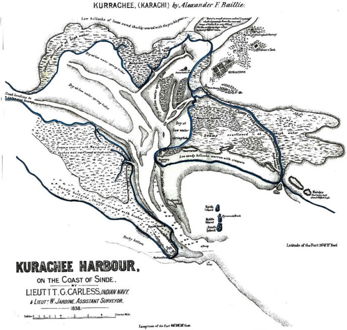
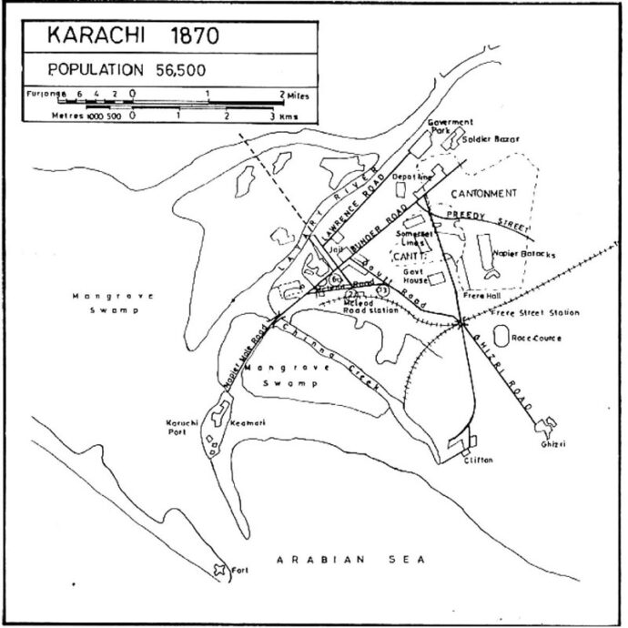
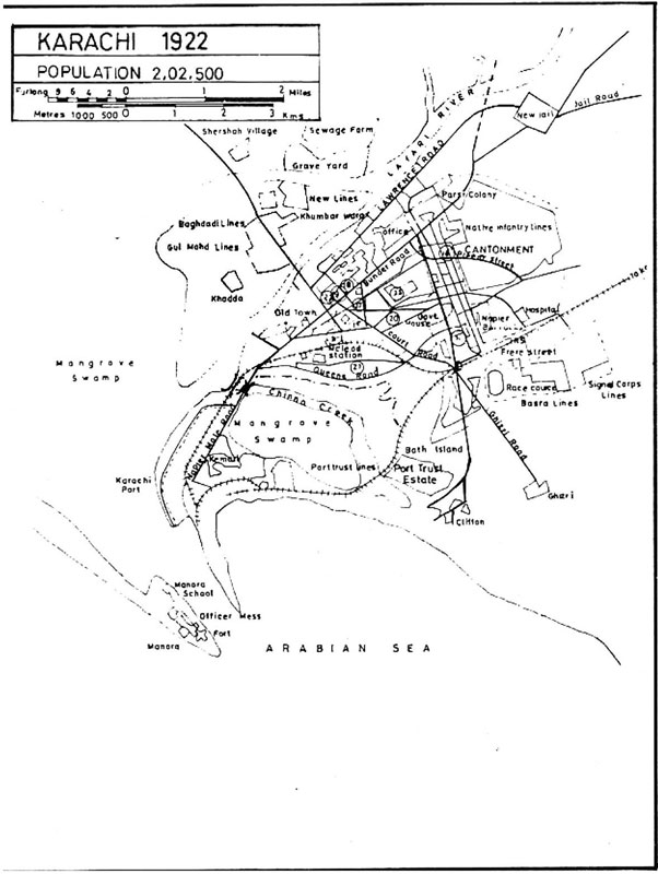
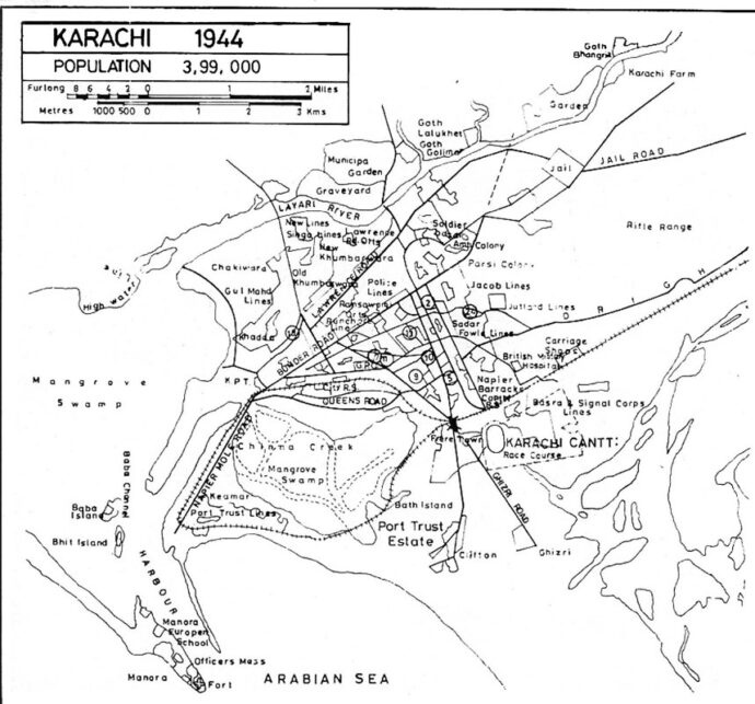
Map-I: Historic maps of the city from 1838-1944.Source: Arifhasan.org
As Karachi’s port economy flourished, most of this growth was absorbed by the inner-city area that accommodated offices, retail outlets, and warehouses for both Indigenous and European traders and merchants, attracting laborers from the rural hinterlands in Sindh who occupied the areas closest to their sources of employment. Consequently, the area became overcrowded, and the land values rose dramatically in the city center. Due to the ‘opaqueness’ of this original part of the city and the outbreak of plagues, the British brought town planning interventions in the form of removal to realign with the addition of infrastructure, dispensaries, and schools.As Karachi’s port economy flourished, most of this growth was absorbed by the inner-city area that accommodated offices, retail outlets, and warehouses for both Indigenous and European traders and merchants, attracting laborers from the rural hinterlands in Sindh who occupied the areas closest to their sources of employment. Consequently, the area became overcrowded, and the land values rose dramatically in the city center. Due to the ‘opaqueness’ of this original part of the city and the outbreak of plagues, the British brought town planning interventions in the form of removal to realign with the addition of infrastructure, dispensaries, and schools.
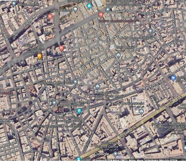
Map II: Map showing organic growth and congested inner streets of Old Town, Karachi.
The narrow, crooked streets, as attributed to the Indian towns by Mr. A.E. Mirams[1] (1923), unlike well-laid out broad roads, distinguished the native towns from those of British cantonments. This original part of the city, besides being dense, is also described as being multi-ethnic in the accounts of Lokram Dodeja and Seth Naomal Hotchund, who highlighted that the businessmen (Seths) shared the same space of the quarter with the lower caste Chappars and Sehtas. The demographic composition of the area pre-partition was such that there were mohallas (neighborhoods) of Muslims and Hindus in the old city, with the Hindu population a majority in the old town. Interestingly, the religious spaces of both Hindus and Muslims existed in close proximity and it is believed that both the religious denominations lived in harmony.
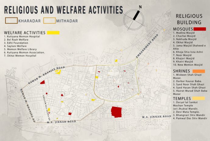
Map III: Map showing religious and welfare activities in the area.
Post-independence in 1947, Karachi as the administrative and economic capital of the newly founded state of Pakistan brought in a refugee influx, which resulted in squatter settlements in the old town area. Most of the functions were within walking distances, and Karachi became a high-density compact city, allowing interactions between intellectuals, politicians, students, diplomats, businessmen, and the working classes in a common shared space. Industrialization brought in more migrants to serve the port and fishing industry, while the establishment of a transport terminal brought in transport-related infrastructure, wholesaling, and storage facilities, and led to the replacement of the multicultural rich by the middle class. Following this in 1976, Islamization marked an important time in history when major changes were introduced in the land-use of Saddar, such that bars, cinemas, and bookshops were converted into markets and shops (Hasan, A. 2010). In terms of socio-political life in the Old Town during colonial times, Panchayats (associations) of residents were formed to negotiate with the municipality. Later, the Jamaats emerged as a reconstitution of local Panchayats into civic associations amongst the merchant classes. Memons come from a lineage of Muslim trader-bankers who attained power and political influence in India during the late eighteenth century. After independence, these new migrants formed their associations on the similar traditional model that existed in Mumbai and Gujarat. The most important of these are:
Kutiyana, Bantva, Veraval, Dhoraji, Wadla, Vanthal,i and Aajak[2], while some recognized themselves as Syeds[3].
Today, most of the inhabitants of Old Town identify as Ahl-e-Sunnat[4], while there is a sizeable minority of Bohras[5], Ismaili[6], and Ahl-e Tasheeh or Shias[7], whose religious centers in the form of Imambargahs and Jamaat Khanas proliferate in the quarter. While the area is a mix of different ethnicities, there is a predominance of Memons who are Gujarati-speaking Muslims that hailed originally from the west coast of India from the regions of Gujarat and Kathiawad. The diverse lineages and identities of all of these groups are also reproduced in the spatial organization of the old city, where each Jamaat has its own schools, community halls, marriage halls, and housing co-operatives (Viqar, S. 2016), dictating the urban life in this part of the city.
Where Communities Lead: Streets, Patterns, Landmarks, and Vocabulary that Tell Urban Tales
The street patterns in the old town area are narrow, haphazard, and disorderly, unlike the grid-iron pattern symbolic of colonial planning. As pointed out in the earlier records of A.F. Bellasis from 1853-59, the existing habitation in the old town lacked ‘order or classification,’ and the registration of property was introduced to determine the precise location of land and the identity of its owners to avoid the ‘good houses getting mixed up with hovels and huts, – the Native population with the European and the poor with the rich.’ This proposes an idea that the native population lacked interest in property registration and lacked order in their lifestyle, as evidenced by these historic records.
The lived space of Karachi, as found by the British, consisted mainly of the walled city that contained both the residential and the commercial establishments. Early British administrators saw the walled city area as an unsatisfactory urban arrangement on several levels. It was considered too congested, obstructing the ‘free circulation of air,’ even though there were wind towers channeling the south-blowing wind into the adobe houses. Also, there was no concept of footpaths in the streets of native towns as they were not acquainted with them, unlike the British, which can be seen even today (Viqar, S. 2016). Narrow, congested lanes with disorderly planning, without the concept of footpaths, was also attributed with Indian style of living in the British records.
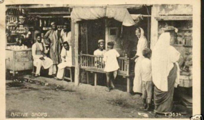
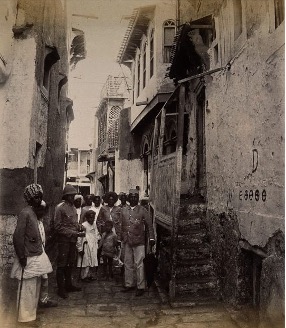
Figure I (a,b): Historic pictures showing the irregularity of streets and absence of footpaths in historic Old Town, Karachi. Source: Karachi City Group, Sindh, Pakistan https://www.facebook.com/groups/194310214411607
To date, the area is known for serving multiple functions in dense historic character. The land-use study of the area suggests that most of the buildings in the area house commercial activities on the ground floor, whereas the upper levels are residential, giving an idea that people work and live in the same area without having to travel.
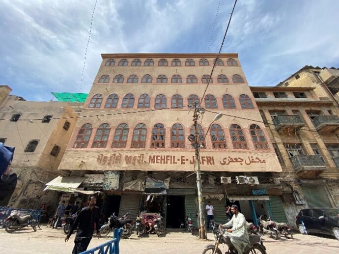
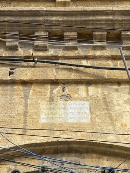
Figure II: Buildings with scriptures in Gujarati, English, and Urdu languages commonly understood by the local population.
With Gujarati being the most-spoken language among the earlier settlers as well as the new migrant Memon population, most of the buildings were labelled in Gujarati (the script of which is still found on the plaques of most of the buildings). Other than this, there was a customary practice to label the buildings in other languages that were commonly understood during that time (i.e. Urdu and English, as well as Sanskrit).
With the dominance of the Memon community, one may point out the community welfare activities considered as a common trait of this community, ranging from free drinking water facilities at various points to free food distribution and free/subsidized hospitals and dispensaries. Other than these, donation boxes are publicly installed for the people to contribute to run the welfare activities.
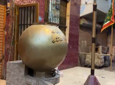
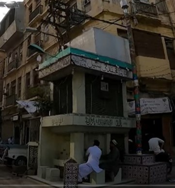
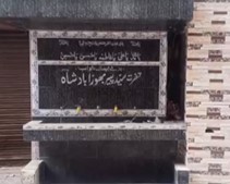
Figure III: Drinking water facilities, locally called ‘sabeel,’ are available at many points. Source: Author.
The buildings that still stand today also exhibit variety in terms of the architectural practices of the historic times, such that there are traces of buildings made in adobe construction, while a sizable number of stone buildings are still present, exhibiting local architectural features as well as adopted British style. The adobe style of construction was commonly used by the native population inhabiting the area, while the stone construction became more popular with time, showing architectural features as an emblem of their identity.
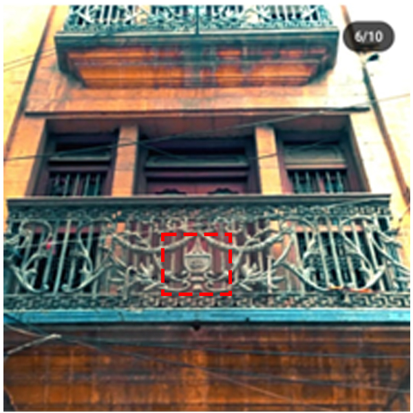
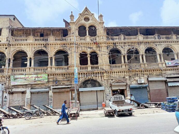
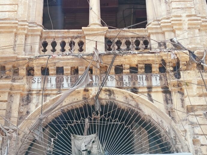
Over the years, the area has witnessed significant changes due to shifts in communities, planning regimes, and political influence, leading to diverse local streets and landmark names. Evidence of the area’s origins as a fisherman village is reflected in places like Nakhuda Masjid (where “Nakhuda” means boat captain), Macchi Miani market (a fish trading hub), and fishermen’s graves. The presence of religious sites such as Imam Bargahs, mosques, shrines, and temples, many over 300 years old, also traces the historical settlement of Hindu and Muslim merchants. British colonial influence is evident in street names like Harris, Newnham, and Younghusband roads, but post independence, many English and Hindu names were replaced with Muslim names to reflect the new sovereignty, such as Newnham Road becoming Fakhr-e-Matri Road and Karsandas Mooljee Jaitha Cloth Market being renamed Cochinwala Cloth Market.
Old Town: Past, Present and Future
The uniqueness of Old Town lies in the fact that the area has been subject to transition since the very beginning, i.e. from once being a home to an indigenous fisherman community, to housing merchants from nearby locations, to adapting to the changes as directed by the British leadership, and, during independence in 1947, the local population being replaced by the new migrant population (mainly Muslims) from the Indian sub-continent. The area thus adopted new characteristics to house the new population that settled there. The area is also witness to the post-independence change, i.e. from being impacted by the planning regimes for the city to the overall character of the city being converted to add an Islamic touch, such that the local vocabulary and the architectural features being developed by the Hindus and Sikhs were modified to give a new Muslim identity to the area.
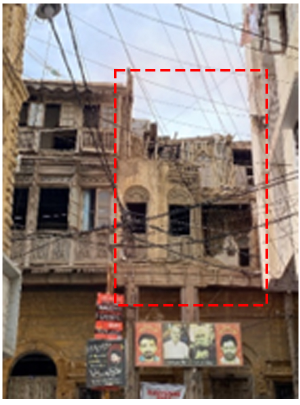
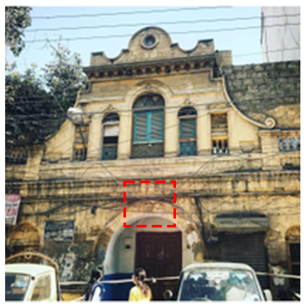
Functioning as an active commercial area today, there are encroachments of all sorts in the area, with the housing demand by the working class serving in the commercial markets in the area leading to addition of stories above the existing buildings, in addition to market activities spilling out onto the streets.
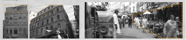
Figure IV: Images showing both horizontal and vertical based encroachments in the area. Source: Sikander et al., 2024.
However, with real estate pressure also comes the threat to old developments, as there is a greater tendency among the builders to pull down a historic building and replace it with a higher apartment building to house more apartments within the same space. The increasing density in the area is exerting great pressure on the existing infrastructure. This rapid transformation is nothing but a threat to the historic character of the area.
Besides all of these factors, the socio-cultural life in the area is very active, especially on the eve of special holy months, such as Muharram, Rabi-ul-awal, Ramadan and Eid (names of Muslim occasions). Other than these, the area has also gained popularity due to its gastronomical activities, attracting people from different parts of the city.
The stories of place-making in the area are more about power, politics, and sovereignty with the greater hold of Jamaats. These Jamaats are not only involved in the management of commercial activities, but are also responsible for maintaining religious spaces, shrines, schools, and hospitals, and indulge in the provision of drinking water and free food to the needy ones. In short, the associations dictate the social life and the day-to-day affairs of the area.
The cultural plurality of the Old Town area with a very dynamic daily life, while being historic at the same time, makes its future hinge on a delicate balance, such that this part of the city cries to be preserved as a part of cultural heritage while also coping with the demands of urban modernization.
Karachi, being the largest city of Pakistan, is on the face of rapid urbanization, which threatens the architectural and social fabric of its oldest neighborhoods. In the wake of this and neo-liberal urban policies, the historic part of the city is struggling to retain its identity amidst commercial encroachment and inadequate infrastructure (Sikander et al., 2024). While scholars (Assmann, 2011; Nora, 1989) argue how crucial the process of preservation of cultural memory is for the character retention of the city, challenges such as overcrowding, lack of amenities, real estate pressure, excessive commercialization, and issues of property tenure are some crucial factors that continue to push the area towards neglect (Hasan, 2010; Ahmed, 2014).
References
Notes-
[1] A.E. Mirams, A Report on the Development of Karachi.
[2] Kutiyana, Bantva, Veraval, Dhoraji, Wadla, Vanthali and Aajak– Associations of Memon jamats (communities) in Old Town Karachi, corresponding to towns in Gujarat, India, from where many Memon families migrated, particularly during the partition of India in 1947.
[3] The Syeds are the custodians and gaddi-nashins (holder or occupier of a certain position) of the Sufi shrines that proliferate in the quarter.
[4] Ahl-e-Sunnat is a significant Islamic sect within Sunni Islam, often referred to as Sunnis.
[5] The Bohra community is a distinctive group within Shia Islam, specifically part of the Ismaili sect known for their keen sense of community, business acumen, and commitment to education and social development.
[6] The Ismailis are a significant branch of Shia Islam, distinguished by their unique beliefs, practices, and social organization.
[7] The Ahl-e-Tasheeh refers to a significant sect of Islam, referred to as Shias.
References-
Ahmed, A. (2014). Karachi: Ordered disorder and the struggle for the city. Oxford University Press.
Appadurai, A. (1996). Modernity at large: Cultural dimensions of globalization. University of Minnesota Press.
Assmann, J. (2011). Cultural memory and early civilization: Writing, remembrance, and political imagination. Cambridge University Press.
Hall, S. (1996). Introduction: Who needs ‘identity’? In S. Hall & P. du Gay (Eds.), Questions of cultural identity (pp. 1–17). SAGE Publications.
Hasan, A. (2010). Karachi: Growth of a metropolis. Oxford Publishing.
Khan, A. A. (2010). Karachi: Megacity of our times. University of Karachi Press.
Lefebvre, H. (1991). The production of space. Wiley-Blackwell.
Lynch, K. (1960). The image of the city. MIT Press.
Massey, D. (1994). Space, place, and gender. University of Minnesota Press.
Mirams, A. E. (1923). A report on the development of Karachi. Government Central Press.
Nora, P. (1989). Between memory and history: Les lieux de mémoire. Representations, 26(1), 7–24. https://doi.org/10.2307/2928520
Sikander, F., Memon, S. R., Zaheer, M. S., Arain, F. J., & Bano, H. (2024). Kharadar’s identity, history & memory in the port city of Karachi: A review. Journal of Liaoning Technical University (Natural Science Edition). https://www.researchgate.net/publication/383276258_Kharadar
Viqar, S. (2016). Sovereignty, modernity and urban space: Everyday socio-spatial practices in Karachi’s inner city quarters (Doctoral dissertation, Concordia University). Concordia University. https://spectrum.library.concordia.ca/980359/