Navigating flash floods and dengue clusters: Maintaining the urban rhythm of life through environmental apps
Digital monitoring technologies are often regarded as smart solutions to various urban challenges, including flooding and water scarcity (Augusto, 2021). To promote sustainability and bolster urban resilience, a continuous stream of data from different types of sensors is integrated into urban infrastructures, enabling smart urban environmental management (Bouroche & Dusparic, 2021). Occasionally, urban environmental data is shared with citizens through specific applications designed to inform the public about potential issues and provide guidance on appropriate actions (Graminius & Haider, 2025). However, the narratives embedded in these applications are rarely examined—insights critical for sustainable transitions and associated actions aimed at mitigating environmental problems. Indeed, beyond informing citizens about environmental matters and suggesting suitable responses, such devices also narrate urban life in particular ways. But what exactly do they narrate? And what implications does this have for the overarching goals of “smart city” technology to improve sustainability?
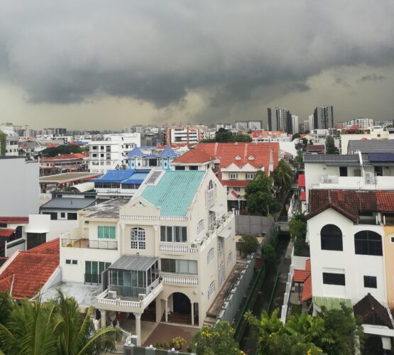
This article explores the narratives and worldmaking of MyEnv—a popular Singaporean smartphone application that delivers real-time information on local environmental issues derived from digital monitoring infrastructures. Singapore is globally renowned as a sustainable, highly developed smart city (Woods et al., 2023). As an island and city-state with high population density and a population size of 6.1 million (Singstat, 2025), it is often described as the “garden city” in Asia and recognized for world-leading water management, vertical gardening, and sustainability practices (Schauenberg, 2024; Wang, 2024). Although all residents live in metropolitan areas—there are no rural settlements (Raihan et al., 2022)—the government has, under the ethos “a city in nature,” fostered a greening of the urban environment through technically informed horticulture, extensive water management systems, tree-planting initiatives, protected biospheres, green buildings, and green leisure zones (Bernard & Heng, 2014; Picture 1; Shee et al., 2024).
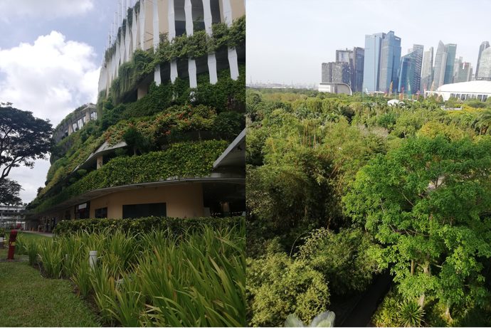
As a low-lying coastal state, Singapore’s greening efforts have also involved protecting land through hard sea structures (Raihan et al., 2022). This vast engineering of the urban environment is supported by advanced monitoring infrastructures for flooding, water quality, and other environmental factors (Schauenberg, 2024). Through its emphasis on technological and ecological solutions combined with high levels of economic development and population density, Singapore has been described as emblematic of this transition, leading the world into a new era of ecological modernization (Wang, 2024, pp. 6–9). However, as data centers increase Singapore’s energy consumption, concerns about environmental sustainability have emerged in relation to the dependence on digital infrastructures (Foong et al., 2024). Another significant concern is the top-down political construction of a green landscape and green management, which may obstruct ecological engagement and awareness among citizens (Shee et al., 2024; Woods & Randle, 2025). Moreover, Singaporean environmental and population management are often intertwined, potentially compromising ecological sustainability (Usher, 2024). As Usher (2024) notes in their analysis of Singapore’s historical modernization processes, the government legitimized and depoliticized population resettlement through expansions of water catchment areas and anti-pollution measures. Environmental urban management thus holds the capacity to depoliticize and normalize government policies and urban lifestyles while simultaneously downplaying ecological sustainability and citizen engagement.
Sharing urban data and shaping urban environmentalities: The MyEnv app
Ecological modernization in Singapore is generally a top-down initiative enacted by government agencies (Wang, 2024). Citizens are encouraged to share in this vision of eco-modernization, particularly through “harnessing digital technologies to empower communities” and “improving the urban environment” (Singapore City Gallery Exhibition, 2026).
As part of Singapore’s digitization efforts, a prominent app is MyEnv. According to official statements from 2025, the app has achieved over one million downloads (NEA, 2026a), indicating that approximately one-sixth of the population uses it. In promotional materials, MyEnv is presented as an app where users can access “timely information on Singapore’s weather, air quality, dengue hot spots, water levels, flood alerts, water disruptions, heat stress levels and more” (NEA, 2026b). MyEnv—short for “my environment”—is a platform that integrates data and alerts on weather, flooding, water quality, public sanitation, and health issues. It also suggests appropriate measures for hazards such as mosquito-borne illnesses and heat stress. Singaporean residents can pay utility bills through the app or report environmental concerns (e.g., localized flooding). Users may also ask questions to three chatbots. The app is jointly developed by three governmental agencies under the Ministry of Sustainability and Environment: The National Water Agency (PUB), the National Environment Agency (NEA), and the Singapore Food Agency (SFA). Prior to 2021, MyEnv only displayed weather, air quality, and dengue-related data. In 2021, PUB and SFA joined the initiative, expanding its scope to include water services and food safety information (Begum, 2021).
Based on this integrated approach to environmental issues, widespread adoption, and strong ties to urban governance, MyEnv constitutes a mundane environmental knowledge infrastructure catering to Singaporeans. It can be likened to a digital flow that people move through in their daily lives (Pink, 2012, p. 34). Indeed, digital flows—whether encountered while scrolling social media feeds, navigating advertisements during streaming content, or checking updates on weather apps—enter our everyday routines and become part of our mundane meaning-making (Moran, 2009; Pink et al., 2017). In particular, digital representations and data enter daily life through smartphone applications and often integrate into our habits (Pink et al., 2017). Given Singapore’s commitment to enhancing the urban environment via digital technologies and its linkage between environmental governance and political legitimacy (Usher, 2024), the discourse surrounding commonplace digital portrayals of the environment warrants deeper analytical scrutiny.
Efficiency, ruptures, and rhythm: Temporal dimensions of management, urbanity, environment, and the everyday
MyEnv is presented as an everyday, mundane tool for accessing timely information (NEA, 2026b). The emphasis on mundanity and timeliness thus defines temporal states through which the app is used and appreciated. Drawing on this, I explore the narratives in MyEnv using a temporal analysis.
In “The Time of the State,” Dalsgaard (2013) argues that temporality and temporal practices are ways in which governments reproduce themselves and embed their governance structures into everyday life. Similar arguments have been made by scholars who show how colonizers imposed—and still impose—their temporal rhythms on colonized populations, thereby shaping native life to fit state needs (Rifkin, 2017). Although these examples concern human subjects, recent research shows that neoliberal forest management practices are at odds with the natural temporal rhythms of trees and harm local ecosystems (Lewis & Gabrys, 2024). Indeed, the management of non-sentient elements, such as water and air, has been criticized for disregarding their intrinsic rhythms (Bailey-Charteris, 2024). This raises questions about how natural elements are incorporated into urban governance and represented in MyEnv.
Turning the lens to urban management—of which MyEnv is a public extension—reveals various temporal structures tied to this practice. First, urban management involves planning ahead and anticipating future events. As a form of planning, it enacts specific future visions in the present (Adams et al., 2009; Anderson, 2010), making it as much about the future as the present. In that sense, management is interlinked with anticipation—a regime in which one inhabits the present as if it were the future (Adams et al., 2009, p. 247). Second, technological dimensions of urban management—such as digital infrastructures—signal desires for temporal reduction and efficiency. As observed in narratives of smart cities, data infrastructures are meant to speed up time to make things more efficient (Bouroche & Dusparic, 2021).
In fact, there are multiple ways through which time and temporality shape urban management, environmental protection, digital infrastructure, and our understanding of what constitutes “the everyday.” Lynch (1972) argues that we experience time through the body and space—everyday rhythms are embedded in bodily and spatial patterns. When environments change or face ruptures, a person’s internal rhythm may diverge from the surrounding conditions (Lynch, 1972). In relation to environmental apps, this dimension is particularly relevant because “the environment” in question is a digital version of physical space. Thus, these apps represent multidimensional spatiotemporal encounters in daily life. Moreover, technology and digital infrastructures are often described as accelerating the everyday (Rosa, 2013), with efficiency gained through AI, data, and sensors. To Rosa, acceleration means the shrinking of present time, which alters our practices and perceptions. An environmental app like MyEnv may thus accelerate everyday rhythms, negotiate environmental experiences, or reframe them.
To add complexity to these temporal layers, climate-related issues are characterized by temporal collisions: society’s rapid pace contrasts with nature’s slow, rhythmic cycles (Rosa, 2013). For example, sea-level rise and biodiversity loss represent future threats that require present engagement (Granjou et al., 2017). Thus, environmental predictions also guide current actions (Adams et al., 2009). When temporal thinking is expanded to include non-sentient entities (Kisby, 2025), water and air—key components of MyEnv—exhibit distinct rhythms with a natural pulse. The tropical monsoon in Singapore follows annual cycles; tides follow lunar patterns; the hydrological cycle defies linear time (Bailey-Charteris, 2024). The temporal perspectives offered by an environmental app like MyEnv can thus be diverse, contradictory, cohesive, or generate new rhythms.
Walking through MyEnv: Navigating flash floods and dengue clusters
I download the app from Google Play Store because I have an Android device. I tick the boxes and select all features it offers. Some are preselected, indicating they are most important; others optional. Then I proceed to walk through the app.
A walk-through method is used here to study how users interact with the app—emulating everyday use as a form of data collection (Light et al., 2018). As stated in my research notes, this begins with registration and downloading, followed by exploration of typical usage. The focus is on identifying the app’s vision, purpose, political and economic interests, and how it regulates user behavior (Light et al., 2018). More concretely, the method involves a “step-by-step observation and documentation of an app’s screens, features, and activity flows—slowing down mundane actions to make them salient” (Light et al., 2018, p. 882). This approach shares similarities with autoethnographic methods (e.g., Cousineau et al., 2019). However, the walk-through is focused on emulating everyday use as an analytical close-up. A key difference from traditional autoethnography, which often emphasizes long-term immersion, is that walk-throughs are shorter in duration. My own walk-through involved both a simulated slowdown and a longitudinal approach: I recorded and analyzed my app usage over three months—one month before arriving in Singapore, and two months after arrival.
The construction of urban environment in MyEnv: Alerts and urban rhythms
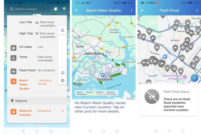
The preselected features of the application include: heat stress, air quality, flash flood alerts, high- alert advisory, and dengue/Zika/Aedes clusters. I keep these options checked and continue to choose all additional features available: temperature, wind, precipitation, UV index, regional hazards, lightning, heavy rain warnings, drain water levels, water supply disruptions, food establishments, hawker centers, astronomical data and tides, as well as beach water quality (Picture 2).
Three of the preselected features reflect environmentally critical issues that may cause immediate disruption or life-threatening consequences: heat stress, flash floods, and high-alert events.[1] Their temporal dimensions relate to ruptures—events disrupting daily rhythms (Lynch, 1972). Climate change is known for unpredictable precipitation patterns and rising temperatures (IPCC, 2023), with flash floods and heat stress as possible manifestations. By incorporating these features into the preselected set, potential disasters enter the present horizon, becoming part of everyday life—even if not directly experienced, they are reminders of what might happen.
The temporal dimension here is anticipation—a present oriented toward future scenarios (Adams et al., 2009; Anderson, 2010). Admittedly, the same applies to most app features—since the app combines real-time data with forecasts. However, these potential catastrophes differ in severity: they represent major ruptures and discontinuities. For instance, poor air quality or dengue may pose long-term health risks but are not immediate threats. They fit within anticipatory thinking, scanning for future problems, but do not disrupt daily life directly.
In fact, a large portion of optional features falls into this category, constituting possible disruptions to routines without posing immediate danger. As Lynch (1972) notes, everyday life follows certain rhythms that are integrated into space and bodies. The quality of beach water, the hygiene standards at hawker centers and food establishments, and the utilization of water services – all of these factors are part of the daily life cycle in tropical Singapore, which can influence the convenience, routines, or habits of its citizens. This is evident in the app’s recommendations:
When I click on widgets, detailed information appears. In the dengue and UV index sections, preventive advice includes removing stagnant water from flowerpots, using insecticides, or applying sunblock. When checking beach water quality, it’s rated on a scale of 1–3; if below a certain threshold, beaches are closed. Apart from the dengue and UV advice, there is little proactive guidance—most advice is reactive. For example, flash floods have no preventive measures, only warnings to avoid certain areas. You can tap the map for street views and check drainage problems or flood risks. I experiment—there are so many CCTV cameras! But no water-related issues.
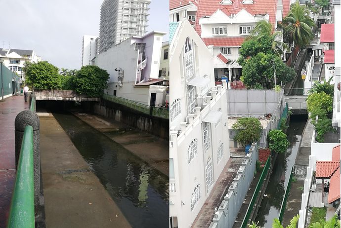
From an urban management perspective, anticipatory work in preventing disruptions is significant. Singapore’s water management systems and sensor networks meant to mitigate future pollution, flooding, and supply interruptions are globally recognized as exemplary (Schauenberg, 2024; Wang, 2024). Artificial canals, streams, coastal structures, catchment areas, and reservoirs serve as tangible symbols of urban planning (Picture 3).
Yet, what MyEnv app users experience is a presentist view—prevention is built into physical infrastructure but hidden from app users. Consequently, the application showcases a model of efficiency – data is disseminated instantly following an occurrence. Indeed, the app is the epitome of the smart city as data infrastructures are designed to enhance efficiency (Bouroche & Dusparic, 2021). But does it make things more sustainable? Does it improve the urban environment?
No—the walk-through reveals that the app does not promote sustainability. It offers no guidance on preventing water disruptions, improving quality, or conserving resources. This stands in contrast to what “smart city” technologies often promise to do, which is to promote sustainability (Bouroche & Dusparic, 2021). Instead, it instructs users on how to respond once issues occur—maintaining a relatively normal daily rhythm in Singapore.
Everyday life in MyEnv: Colliding and synchronized rhythms
Proceeding further through my walk-through, I explore the default main page:
The home screen shows a map of Singapore with a 2-hour weather forecast. Tapping the forecast icon reveals a 24-hour outlook and a 4-day forecast. Below this, various widgets are available—users can switch between temperature, wind, precipitation, UV index, etc., for display on the map. Scrolling down displays all selected environmental parameters. Had I not reviewed alerts or details about beach water, flash floods, dengue clusters, etc., my initial impression would be that MyEnv is primarily a weather app (Picture 4).
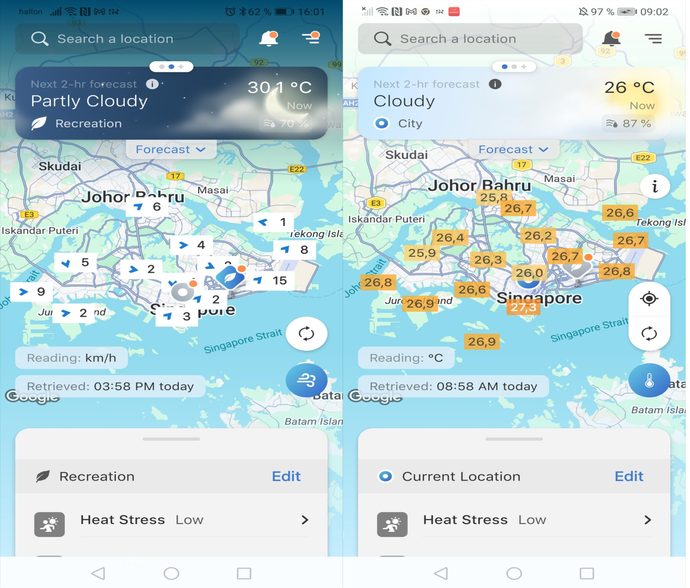
From a temporal perspective, weather forecasts are real-time and future-oriented, and made into common anticipatory features in daily life through apps or TV/radio broadcasts (Stewart & Bolton, 2023). By merging weather with other environmental data with which users may not be very familiar, MyEnv leverages users’ familiarity with routine weather forecasting to create a novel digital representation of the urban environment. In short, the app blends familiar forecasting routines and new “environmental” parameters —making these elements naturalized and entangled in everyday understandings and practices (Pink et al., 2017). Dalsgaard (2013) argues that temporal practices constitute ways in which governments reproduce their worldviews and narrate everyday life. Similarly, by merging weather with other environmental data, MyEnv uses the user’s existing routines of checking forecasts to expand the understanding of what constitutes the urban environment. Thus, governmental narratives are embedded in indirect temporal practices—daily routines and habits.
The user perspective is something I will return to, because as I proceed to use the app for months, I notice discrepancies and contradictions. Why is the app called MyEnv? What kind of environments are really part of my everyday?
One day, an alert appears for a volcanic eruption in eastern Indonesia; another day, an earthquake off the coast of the Philippines. I notice how I enter “alert mode,” scanning for dangers. But three months later, I no longer react. These alerts happen almost daily, yet with no real-world impact. If there’s a volcano eruption in West Papua, why do I get an alert? (Picture 5).
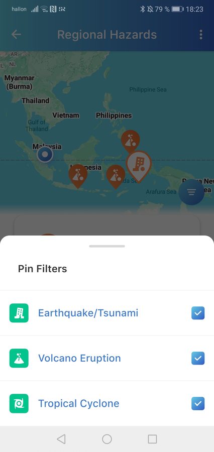
From a temporal perspective, these alerts and data link distant regions and timescales, contributing to the shrinking of time and space (Bouroche & Dusparic, 2021; Rosa, 2013). Events in remote places become emotionally close. Initially, I feel concern and anxiety—but over time, they fade. When real-life events occur, the physical distance between regions becomes apparent; digital alerts appear disjointed and random. I start questioning why these features are included in the app.
In contrast, thunder alerts offer a counterpoint:
I receive thunder alerts almost weekly—they’re timely and localized. I begin to notice them, take precautions if thunder appears. If the sky darkens, I check updates and alerts. The digital and real-world experiences merge and are synchronized.
In this scenario, MyEnv thunder alerts are synchronized with my real-life temporal rhythms, and thus become part of my everyday. In Lynch’s (1972) terms, spatial and temporal dimensions align.
Everyday life in MyEnv: Discrepancies and silences
Proceeding further in my walk-through, I notice tensions and inconsistencies:
One day, smoke fills the air—regional haze from burning forests or peat in Indonesia. It’s carried by the wind into Singapore. But I see no app alerts. In fact, the air quality is rated as good—yet news reports confirm regional haze. Why are there no alerts?
The absence of alerts may stem from a technical bug. But when it persists across other parameters, such as flash floods, I start to question the app:
During a three-month monsoon period, only one flood alert appears. I regularly check the flash flood widget and CCTV features—aside from two high drainage indicators not marked as alerts, no issues are reported. Yet, four news reports mention local flash floods during this time. What’s wrong with the app? Or have I failed to enable a crucial feature?
Apart from constituting an arrhythmic experience of colliding digital and real-life dimensions (Lynch, 1972), there’s another interpretation of this discrepancy: one tied to smart city management, anticipation and political legitimacy.
Urban management of natural systems, like water, is rooted in anticipation—a regime where present life is inhabited as future (Adams et al., 2009; Randle & Barnes, 2018). As displayed in the app, anticipation of events and efforts to control them are also materially manifested by the inclusion of alerts as an app feature. Alerts give the user the initial impression of control. The digital weather map’s display of city-wide CCTV and sensors reinforces this impression of governmental oversight. Similarly, smart city management aims at order, control, and efficiency to improve urban environments (Augusto, 2021). Thus, the initial user experience reflects smart governance—alerts create a sense of control and efficiency. Moreover, the management of natural elements like water and air is an increasingly common feature in climate adaptation planning (Augusto, 2021; Chen et al., 2023). The choice of displayed water parameters in the MyEnv app reflects human needs or worries, such as water supply or risks like flash floods. Yet, rising sea levels and storm waves are not included in the app, despite research showing Singaporeans’ deep concern about rising seas (Yousefpour et al., 2019). These critical indicators remain absent. Hence, my walk-through suggests that only some bodies of water are managed. However, even if the management of natural elements appears extensive, one starts to question the extent of management when alerts fail to materialize over time. Indeed, water is disciplined but also free and unruly; it is managed yet ungovernable. By anticipating its movement, urban management enacts future scenarios in the present, creating an impression of oversight through app features and alerts. Drawing parallels with Usher’s (2024) study on how environmental “needs” legitimize government practices, I argue that data sharing can serve as a tool to promote political legitimacy. The vast resources required for urban environmental monitoring—sensors, CCTV, satellite images, radar, reconfigured landscapes—promote the idea that water and environmental issues are primarily governmental concerns. Thereby, the app also narrates the necessary existence and raison d’être of the government.
Concluding Remarks
The app and its suggested actions aim to sustain a specific urban rhythm of life and services. In light of climate change threats, sustainability and resilience remain narrowly focused on present conditions—the app maintains the status quo rather than creating narratives for alternative futures. Instead, it creates a world designed to help residents navigate environmental obstacles on a daily basis.
The environment as presented in the app includes natural elements used in daily life in various ways (e.g., household water, beach water) or representing potential danger/nuisance (e.g., floods, thunder, heavy rain, heat stress). Ubiquitous digital practices—such as checking weather forecasts—are also part of the app. Thus, urban environments are framed as risks to be managed and anticipated, while also being shaped to fit everyday routines. Indeed, MyEnv functions as a socio-political entanglement: “Environment” becomes both a rhythm of daily life and a potential disruptor (flash floods, pollution). It is simultaneously a government service and a national security issue, presenting the urban environment as a state issue.
As an application intended for everyday use in Singapore, MyEnv’s digital representations of “the environment” enter daily lives and become part of mundane meaning-making (Pink et al., 2017). Through the promoted temporal dimensions, urban life appears as a rhythmic flow vulnerable to occasional disruptions—navigated by the government. Drawing on Dalsgaard’s (2013) view that temporality can be used as a tool to legitimate state visions and practices, I suggest that everyday life seems indeed impossible without governmental management to prevent ruptures. In that sense, the app performs political legitimacy in ways similar to Usher’s (2024) interpretation of environmental management as a tool for legitimizing governance. However, there are cracks in this narrative. When digital alerts fail to align with bodily or spatial experiences—when the app’s rhythms diverge from real life—the perception of environmental management wanes. To properly perform political legitimacy, temporal dimensions in the app must be grounded in citizens’ lived, embodied experiences. As such, it seems, there will always be room for citizens to negotiate, reject or reinterpret their digital experiences of the environment, and perhaps find ways to relate to the urban environment in more meaningful ways.
References
Adams, V., Murphy, M., & Clarke, C. (2009). Anticipation: Technoscience, life, affect, temporality. Subjectivity, 28, 246–265
Anderson, B. (2010). Preemption, precaution, preparedness: Anticipatory action and future geographies. Progress in Human Geography, 34(6), 777-798.
Augusto, J.C. (2021). Smart cities: state of the art and future challenges. In Augsto. JC (Ed). The handbook of smart cities. Springer Cham. 978-3-030-15145-4.
Bailey-Charteris, B. (2024). The hydrocene: eco-aesthetics in the age of water. Taylor and Francis. London.
Begum, S. (2021). New version of MyEnv app includes information on water services and food. Straits Times. https://www.straitstimes.com/singapore/environment/new-version-of-myenv-app-includes-information-on-water-services-and-food
Bouroche, M. & Dusparic,I. (2021). Urban Computing: The Technological Framework for Smart Cities. In Augusto, J. (Ed.). Handbook of smart cities. Springer Cham. 978-3-030-15145-4.
Chen, H., Chen, T.F., Smith, N., & Rangel-Buitrago (2023). Analyzing the impact and evolution of ocean & coastal management: 30 years in retrospect, Ocean Coast Manag., 242, 1-12.
Cousineau, L. S., Oakes, H., & Johnson, C. W. (2019). Appnography: Modifying Ethnography for App#Based Culture. In D. C. Parry, C. W. Johnson, & S. Fullagar (Eds.), Digital Dilemmas: Transforming Gender Identities and Power Relations in Everyday Life (pp. 95–117). Springer International Publishing. https://doi.org/10.1007/978-3-319-95300-7_5
Daalsgaard, S. (2013). The time of the state and the temporalityof the Gavman in Manus Province, Papua New Guinea, Social Analysis, 57(1), 1-12.
Foong, P., Pidani, R., Sithira Vadivel, V., & Dongyue, Y. (2024). Singapore smart nation: journey into a new digital landscape for higher education. In Emerging Technologies in Business: Innovation Strategies for Competitive Advantage, Springer, 2024, pp. 281–304.
Graminius, C. & Haider, J. (2025). Anticipating airpocalypse: Air quality apps and implicit modes of anticipatory practices. Futures 173 (103652): 1-12. DOI: 10.1016/j.futures.2025.103652
Granjou, C., Walker, J., & Salazar, J.F. (2017). The Politics of Anticipation: On Knowing and Governing Environmental Futures. Futures, 92. doi:10.1016/j.futures.2017.05.007
IPCC (2023). Climate Change 2022 – Impacts, Adaptation and Vulnerability: Working Group II Contribution to the Sixth Assessment Report of the Intergovernmental Panel on Climate Change (first ed.), Intergovernmental Panel On Climate Change; Cambridge University Press 10.1017/9781009325844
Kisby, N. S. (2025). The sounds of snow: An exploration of human-snow relationships in Ilulissat, Kalaallit Nunaat. In A. Petitt et al. (Eds.), Multispecies ethnography and artful methods, Cambridgeshire: The White Horse Press
Lewis Hood, K., & Gabrys, J. (2024). Keeping time with digital technologies: From real-time environments to forest futurisms. Environment and Planning D: Society and Space, 42(2), 254-274.
Light B., Burgess J., Duguay S. (2018). The walkthrough method: An approach to the study of apps. New Media & Society, 20(3), 881–900.
Lynch, K. (1972). What time is this place? MIT Press. Cambridge Massachusetts.
Moran, J. (2005). Reading the Everyday. London: Routledge.
NEA (2026a). Over 1 million downloads! National Environment Agency, Facebook page. Facebook. https://www.facebook.com/checkpoint/1501092823525282/?next=https%3A%2F%2Fwww.facebook.com%2FNEASingapore%2Fposts%2F932888855652197%2F. Accessed, Jan 23, 2026.
NEA (2026b). About MyEnv. National Environment Agency. https://www.nea.gov.sg/myenv. Accessed, Jan 23, 2026.
Pink, S., Sumartojo, S., Lupton, D., & Heyes La Bond, C. (2017). Mundane data: The routines, contingencies and accomplishments of digital living. Big Data & Society 4(1). DOI: 10.1177/2053951717700924
Raihan A., & Tuspekova, A. (2022). The nexus between economic growth, energy use, urbanization, tourism, and carbon dioxide emissions: New insights from Singapore. Sustainability Analytics and Modeling, 2(12):100009.
Randle, S & Barnes, J. (2018). Liquid futures: Water management systems and anticipated environments. Wires: water, 5(2). 5:e1274. doi: 10.1002/wat2.1274
Rifkin, M. (2017). Settler Time. Duke University Press.
Rosa, H. (2015). Social Acceleration: A new theory of modernity. New York: Columbia University Press.
Schauenberg, T. (2024). How Singapore got a grip on water scarcity. Deutsche Welle. https://www.dw.com/en/how-singapore-got-a-grip-on-water-scarcity/a-70362786
Shee S. Y., Woods, O., & Kong, L. (2024). When planetary cosmopolitanism meets the Buddhist ethic: Recycling, karma and popular ecology in Singapore. Transactions of the Institute of British Geographers, 49(2). https://doi.org/10.1111tran.12654).
Singapore City Gallery (2026). Smart Nation. Permanent exhibition. https://www.ura.gov.sg/Corporate/Singapore-City-Gallery, Private visit, 26 January, 2026.
Singstat. (2025). Population trends 2025. Singstat. https://www.singstat.gov.sg/-/media/files/visualising_data/infographics/population/population-trends-2025.ashx
Stewart, A., & Bolton, M. (2023). Digital Weather Information in an Embodied World. Informatics 10 (1), 13. https://doi.org/10.3390/informatics10010013.
Usher, M. (2024). Territory, hydraulics, biopolitics: internal colonization through urban catchment management in Singapore. Territory, Politics, Governance, 12(6), 846–865. https://doi.org/10.1080/21622671.2022.2056503
Wang, J. (2024). Beyond green skylines: Singapore and the limits of eco-modernism. MIT Press.
Woods, S., Bunnell, T., & Kong, L. (2023). Insourcing the smart city: assembling an ideo-technical ecosystem of talent, skills, and civic-mindedness in Singapore. Urban Geography. DOI: 10.1080/02723638.2023.2233353
Woods, S., & Randle, S. (2025). Ecological responsibility in the city: the surfaces and volumes of urban mosquito management. Urban Geography, pp. 1-23, doi.org/10.1080/02723638.2025.2512068
Yousefpour, R., Prinz, A., & Ng, C. (2020). Public perceptions of climate change adaptation in Singapore dealing with forecasted sea level rise. Human and Ecological Risk Assessment: An International Journal, 26(6), 1449–1475. https://doi.org/10.1080/10807039.2019.1580140
[1] High alerts comprise alerts for volcano eruptions, earthquakes, tsunamis, water scarcity; in short, everything that can go seriously wrong and affect urban life.