
Living Sumud in Area C: Everyday Spaces of Care and Resilience in Beitin Village, Palestine
“In the summer of 2016, when I was in the tenth grade, I stood by the roadside near my house selling figs and prickly pears to earn some money. It probably wasn’t the best spot for sales, as cars would pass many other vendors before reaching me, but I managed to make a small profit in the end.
Two elderly women passed by. To me, it was obvious they must be headed to Deir Dibwan, as it was the only neighboring town I knew in that direction. I asked them where they were going, and the answer was: ‘To Burqa!’
I was baffled. Burqa was at least a fifteen-minute drive away, how could they be walking there? I asked them, confused. One of them replied with equal surprise, ‘No, it’s not far at all! Look, there is Burqa,’ and she pointed toward the southeast.
According to everything I knew, the path she pointed to led to nowhere… a dead end. We had never traveled that way before. I wondered if she was mocking me. That path was a ‘blur’ in my mind; I knew it was closed, but I didn’t know why, or where it used to lead.
That evening, I asked my mother. To my surprise, she confirmed the old woman’s words. She told me that the mountain path does indeed lead to Burqa, but it had been closed long ago, before I was even born.
Perhaps my financial profit from selling fruit wasn’t great that day, but I gained something far more valuable.”
Introduction
The above personal story is inseparable from a broader system that constrains the Palestinians’ spatial imagination. It reveals a lurking and escalating danger that has affected successive younger generations. What appears as an individual experience is therefore also symptomatic of a wider regime of colonial spatial control that shapes the younger generation’s capacity for imagination and mobility.
Colonial violence extends beyond physical destruction to erode memory and spatial consciousness. Its most insidious effect lies in normalizing the fragmentation of the Palestinian space, as successive generations lose sight of what once existed and what their struggle seeks to reclaim. “Colonialism is not satisfied merely with holding a people in its grip and emptying the native’s brain of all form and content. By a kind of perverted logic, it turns to the past of the oppressed people, and distorts, disfigures and destroys it” (Fanon, 1963, pp. 210–211). The impact of space fragmentation on the young people’s spatial imagination is particularly evident in the context of restricted mobility. For example, the segregation and restriction of mobility in Nablus city have significantly affected the spatial imaginations of the young generation. Abujidi (2009, 284) explains that “the forced city arrests have led to a very abstract and limited perception and imagination of the outer spaces, cities, and the world in general among the younger generation.” Scholars view spatial imagination as the mental recognition of space, which may differ from its objective physical reality. “Each person, it seems, lives in his own personally constructed web of spatial relationships, contained, as it were, in his own geometric system” (Harvey, 2010, p. 34). Harvey added that each person has a “unique image” while a group of people may have common elements in their perception of the space which creates the “common image.”
Erasing collective memory goes beyond the destruction of physical traces, such as cities and villages. It disrupts historical continuity and reshapes the very framework through which people perceive space and belonging. This process operates not only through tangible and visible interventions, but also through an invisible layer of legal regimes, planning mechanisms, and everyday lived experiences.
In the past, rural boundaries were fluid and socially defined; the precise edge of a village was rarely fixed or significant. A village’s limits were understood relationally by the furthest cultivated land, the last neighboring household before another community began, or the grazing range accessible to a shepherd and his herd.
Today, however, the definition of the village boundary has been restructured by the colonial apparatus through land division, zoning, and barriers. Movement is now regulated by clearly demarcated lines that determine where residents may and may not go. As a result, both physical and psychological boundaries have solidified, transforming previously open landscapes into segmented and restricted spaces. In the following sections, the article will delve into the terrains of Beitin village in the governorate of Ramallah and Al Bireh, trying to understand the impact of settler-colonial apparatus on the local residents’ imaginaries and the everyday practices of resilience that they have developed to sustain their lives in the village.

In Beitin village, residents’ spatial awareness has been profoundly reshaped by colonial infrastructures and insertions, such as Road 60 and other bypass roads, the Givat Asaf outpost, land classifications, the Beit El settlement, and the DCO checkpoint, as shown in Figure 2 below. Together, these interventions reconfigure not only the physical landscape but also its cognitive representation, altering how residents perceive movement, proximity, and belonging.
To examine this phenomenon, the article adopts a qualitative methodology that intersects archival data with personal narratives. The article illustrates the different settler-colonial elements that impact the village landscape through archival mapping and explores the impact of each through storytelling and mental mapping approaches. In these sessions, locals narrate and draw their own experiences within this contested landscape. By targeting different age groups from both genders, the study aims to document the generational disparity in spatial recognition and the gradual erosion of geographic continuity in the collective memory of the village. On the other hand, the article highlights the everyday practices of Sumud, an Arabic word that refers to remaining, persevering, continuing, and enduring, and is literally translated into steadfastness in English. According to Hammad and Tribe (2021), the concept of Sumud varied among Palestinians, ranging from small individual acts, like smiling at a military checkpoint or insisting on enjoying life despite difficult circumstances, to social solidarity, resisting home raids, and boycotts.

The settler-colonial apparatus and the Palestinian villagescape
The phenomenon of settler-colonial spatial violence is inextricably linked to state-led mechanisms, functioning as a dual-faceted system of control. In the village of Beitin, as in numerous Palestinian rural communities, this violence is operationalized through a complex matrix of land classification, confiscation, prolonged road closures, and military incursions, which often serve as a precursor to settler raids.
Central to this systemic violence is the administrative classification of land. With over 75% of village lands designated as ‘Area C,’ the territory is subjected to restrictive Israeli military jurisdiction, rendering urban expansion virtually impossible. According to Shalev et al. (2008), Palestinian development in Area C is stifled through a combination of outdated legislation, lack of representation, and the enforcement of antiquated master plans. These restrictive measures are further compounded by legal misinterpretations and a prohibitively complex licensing process that systematically denies building permits.
This regulatory confinement has left the village’s urban fabric fragmented and vulnerable. Furthermore, these lands function as “buffer belts” surrounding arterial infrastructure and existing settlement lands that have already been confiscated to secure future expansionist projects. This threat extends beyond architecture to the agricultural sector; under the pretext of security, specifically the claim that “saboteurs” utilize the landscape for cover, the military has carried out extensive land-clearing operations, such as the mass uprooting of olive groves adjacent to Road 60.
Bypass roads
The planning of bypass roads and Road 60, in Beitin and elsewhere, was far from neutral. Stretching from the southern to the northern West Bank, this established a rigid physical boundary that gradually has become normalized in everyday life. As Figure 2 shows, the road separated a large percentage of Betin’s lands from the known center of the village.
From the beginning, the road was designed to serve the apartheid vision, not to integrate with the Palestinian fabric, where the street could have merged with the Palestinian roads via roundabouts, which could have created a strong node. Instead, it was raised on rubble, and Palestinian roads need to go beneath it in tunnels, or the high-speed road is raised with bridges. The massive embankment of rubble has violated the local topography and created artificial ridges that block both physical and visual connectivity.

Deir-Dibwan Bridge (shown in Figure 3), as its name suggests, represents the beginning of the neighboring town Deir-Dibwan and creates a strong landmark in residents’ minds, while in reality the village lands extend far into the lands that are commonly known to be Deir-Dibwan’s lands.
Settlements & outposts
Roads 60 and 466 were not the only multidimensional barriers that limited spatial awareness. Givat Asaf outpost, established in 2001 on the road junction between road 60 and road 466 on a hill of Beitni’s lands[1], has played a strong role in reducing spatial awareness. Settlements that are built at the crossroads do more than just control and monitor the streets and villages; they create a psychological barrier of fear of getting closer to them, and they have become ‘blurry spots’ in people’s memory. Even though they are known to be illegal, we have subconsciously started treating their borders as the end of our world. This is especially true for the younger generation, who grew up never being able to reach those lands.
Checkpoints and permanent closures
Checkpoints and street closures are not separate entities from the existence of settlements. They are necessary to prevent the Palestinians from approaching their lands near settlements or nearby villages, thereby maintaining the isolation of Palestinian communities from lands near illegal settlements. For instance, after Givat Asaf outpost was established, the street connecting Beitin and Burqa was closed by gates and dirt barricades from both sides to block the Palestinian approach to road 466 (as shown in Figure 2).
The closure also affected the spatial imagination on a larger scale, distorting our imagination of the relationship and the distance between our towns and cities. The DCO checkpoint refers to the District Coordination Office that is located in the area. The checkpoint separates Beitin from Al-Bireh city.
For 13 years (2002–2015), the closure of the DCO checkpoint forced Beitin’s citizens to take a much longer route. So, until 2015, those born after the 2000s believed that Al-Bireh city was 45 minutes away, whereas it only took 5 minutes when the checkpoint was open. When the checkpoint is closed, the alternative route goes through Ein Yabroud, Dura Al Qari’, Al-Jalazon, and then the street near Sorda. This detour is necessary to bypass Beit El settlement, eventually reaching the same point that could be reached in 5 minutes if the checkpoint wasn’t there. See Figure 4: Two Ways to reach Al-Bireh.

The DCO was opened on May 25, 2015, solely for entering and leaving the city (for those with VIP cards). It alternated between opening and closing for two years until it was finally accessible in both directions in 2017. However, the Israeli military retains the authority to control the checkpoint and can close it at their discretion, for hours or even weeks. The DCO checkpoint has been closed again since October 7, 2023.
Land classification
Land classification works in parallel with all of the above, since building regulations keep Area C empty of buildings, which reduces the existence in the district, making it non-vital and thus an ignored and unrecognized area, which also makes it weaker against settler attacks.
Military decisions and settlers’ attacks
Military regulations and administrative protocols fundamentally facilitate settler-led aggression. A primary manifestation of this is systematic arson targeting expansive mountainous slopes. The destructive capacity of these fires is exacerbated by jurisdictional constraints; since Palestinian civil defense teams are prohibited from entering Area C without prior security coordination, a “response vacuum” is created. Consequently, fires often consume vast tracts of land before authorization is granted, effectively turning bureaucratic delay into a tool of environmental destruction.
Beyond arson, the destruction of the agricultural landscape takes the form of clandestine tree-felling, occurring primarily in areas rendered inaccessible to their owners due to military restrictions. This spatial isolation ensures that such acts of violence proceed without witness or intervention. However, the most acute form of this confrontation occurs during the olive harvest season. The Al-Marj lands, which constitute a vital part of the village’s agricultural heritage, have become a focal point for direct assaults on farmers and lands[2], illustrating how seasonal economic activities are transformed into sites of high-risk conflict. Furthermore, these roadblocks not only isolate the farmer from his field but also hinder residents of neighboring towns from reaching affected areas to provide urgent assistance, thereby severing communal networks of mutual aid.
In Hollow Land, Eyal Weizman (2007) explains the “politics of verticality,” where topography is weaponized to exert control over Palestinian urban spaces. This spatial dominance is demonstrated in the case of Beitin; the elevation of Road 60 on artificial embankments (rubble) creates a vertical hierarchy. This strategic positioning grants settlers a dual advantage of visual surveillance and tactical superiority, effectively transforming the physical landscape into a mechanism of asymmetric power. See Figure 5. Settler attacks in Beitin often utilize a strategic time pattern, primarily occurring during night hours, typically between 00:00 and 03:00, to maximize psychological effect and minimize immediate resistance. These raids are characterized by systematic property destruction, including the arson of vehicles and domestic assets. Documented incidents reveal a coordinated methodology: settlers, often masked to avoid identification, break into residential areas to deploy highly flammable materials, such as gasoline, against private property. This pattern of violence extends beyond expensive property vandalism to include attempted home invasions, where targeting houses is a deliberate step meant to put families’ lives at risk and destroy the safety of their private homes.

Methodology
The research methodology is based on storytelling and critical mapping. By engaging with residents directly in streets and public spaces, we conducted participatory sessions with various age groups of about 15 participants of each gender. Participants were provided with a map of the village that excluded official land boundaries. To assist them, we highlighted key local landmarks, including the bridge, the wedding hall, and the mosque. The residents were then asked to show where they think the village’s boundaries end. Then we asked the same participants how far away they thought Al-Bireh city was from the village before the opening of the check point. The diverse responses across different age groups demonstrate how the occupation, alongside shifts in lifestyle and connection to nature, has profoundly altered the residents’ spatial perception and their mental image of the landscape.

The spatial imaginary of Beitin village under settler-colonial impacts
The mapping exercise results were organized under three main themes: age groups and gender, connection to city, and connection to nature.
Age groups and gender
The first age group to participate in the mapping exercise was teenagers and youths (13–27 years old), whom we reached at a computer PlayStation venue, the university, and through relatives. They drew the border as in Figure 7.

The comparison to the actual registered boundaries of the village demonstrates that most of the young people recognize only 35% of the village area. A large percentage of the forgotten lands are located after Roads 60 and 466, since they created a formidable multidimensional barrier. Beyond the hazard of high-speed traffic, the road imposes a severe psychological edge, where getting closer to the road risks the individuals being accused of throwing stones.
They also excluded the outpost immediately after we had shown them where it lies with all the lands nearby it. Some of them didn’t recognize some houses in Al Harah Al-Sharqiah (meaning the eastern neighborhood) and most recognized only offsets around Area B lands where most of the village houses are located. In some cases, males from the young age group included more lands than females from the same age group. Parents may be concerned about their daughters venturing into potentially hazardous locations, leading them to spend more time at home. Conversely, males of the same age tend to move around more freely.
On the other hand, older generations (ages 28 – 50s) drew different borders, which varied according to their experiences and genders. Since they were born before the establishment of Givat Asaf outpost, they used to utilize the currently closed street between Beitin and Burqa, so they could recognize that the lands where the outpost is located belong to Beitin, but they also hesitated whether the lands beyond it also belong to the village or not.
Connection with nature
Connections with nature have a large effect on participants’ perceptions, since they remember what they used to see. The largest map’s borders (in Figure 8) were drawn by a 32-year-old man who lives in Al-Harah Alsharqiey. He could recognize more lands than others, and when asked how, he demonstrated that he had a strong connection with the landscape when he was young. He and his friends used to go to the water spring in the area even after the outpost was created nearby and they had the guts to fight with settlers just to have this connection with nature. But still, he couldn’t recognize the lands beyond Road 60.

Another participant, 31 years old, stated that he knew almost the exact official borders of the village, even those beyond road 60. When we asked him how he knew, he answered that his family has lands there, and that his father once told him the information and he had once had a look at the map.
Females in the older age groups showed a different understanding. In the beginning, as Figure 9 shows, younger females in the age group 27-48 knew fewer lands, but some of the older women knew almost the exact borders and the lands’ names. One of them talked about the fact that some houses of Burqa are in Beitin’s lands, and that Al-Marj olive trees are also in Beitin’s lands, while most of the other village residents think they’re in Burqa. Although both groups of women under and over 50 years old had lived in the area prior to the establishment of the outpost, their distinct personal experiences and peasant lifestyle could explain the big difference in mapping results.

Connection with the city
Most of the residents between 14-26 years old (born after the year 2000) didn’t know that the distance between Beitin and Al-Bireh actually takes 3-5 minutes until the checkpoint was opened in 2015.
In an interview with a 26-year-old female, she stated “I remember my parents warning me about the checkpoint road when I was a child. Although they told me it led to the city, I couldn’t imagine it being so close. I thought they were exaggerating.”[3] Another male of the same age reported: “My friends and I were fearless; we used to go all the way to the areas near the DCO, fully aware of just how close Al-Bireh city really was.”[4]
This experiment showed how the Israeli changes in the Palestinian landscape had violated spatial awareness, created multidimensional barriers, and blocked connection: physically, mentally, and visually. The damage differed according to age groups, accumulated knowledge, and connection with nature.
Everyday resilience and care practices
In response to displacement strategies, residents have developed multifaceted resilience mechanisms. These include reclaiming land through construction as a form of resilience, architectural modifications for protection, using social networks for rapid mobilization, exploiting topographical privilege for surveilling, and strengthening communal bonds through voluntary duties, cooperation and borrowing. Furthermore, the persistence of daily life despite frequent raids demonstrates a form of ‘everyday resistance’ that challenges the intended psychological impact of occupation.
Building in Area C: resilience through existence and vitality
As explained above, the core of the problem lies in land classification, which rendered Area C non-vital and marginalized. In response, residents have used different methods to build there. One method involves paying exorbitant amounts of money to obtain a building permit; in one case, a house remained unfinished for 20 years until owners had to pay fees that eventually exceeded the actual cost of the building itself (Informal Interview, 2020).
In another case, an individual with dual Palestinian-American citizenship was able to obtain a permit. Later, however, he was restricted to building only commercial and storage floors, despite his original plan to add residential apartments above them as shown in Figure 10. Unexpectedly, even with only the commercial floor completed, the project increased the vitality of the neighborhood. A previously silent area was transformed into a small hub featuring a hair salon, a meat store, a kitchen, a spices store, and an office, attracting visitors from both the village and surrounding areas.

Another common method in Palestine is to take the risk of unauthorized construction. While older houses built before the land classification remain in use, the need for housing grows as sons get married. Families often take the risk of quickly building an additional, unlicensed floor over the original structure, as Figure 11 demonstrates. In another village, there was a notable case of seeking spatial justice: two sons decided to divide their building vertically rather than horizontally. This ensured that each brother held an equal share of both the permitted (legal) and non-permitted (at-risk) sections of the house, creating a fair distribution of security and risk between them. Figure 12 demonstrates how each one had a vertical section of the house.


Architectural modifications
In response to persistent settler attacks, residents are often forced to make an extreme choice between the safety of their homes and their architectural beauty. This trade-off aligns with Maslow’s hierarchy of needs, where physiological and safety needs form the essential base of the pyramid, while aesthetic and self-actualization needs occupy the summit. Consequently, when faced with the threat of violence, residents prioritize survival, effectively choosing to live within ‘fortified cages’ rather than remain in danger.

While sophisticated architectural modifications, such as sun-breakers for glass facades, could provide both protection and beauty, their high costs make them inaccessible for most families. As a result, residents abandon aesthetic considerations in favor of practical defenses, such as installing heavy steel mesh over windows and glass facades (Figure 14). These meshes serve as a primary shield; when settlers throw stones or incendiary bottles, the barrier prevents the glass from shattering and the fire from entering the living space.

Beyond the house itself, the protection of outdoor spaces and large land plots requires strategic financial and physical planning. To secure expansive properties, residents often rely on barbed wire fencing as a primary defense; while high steel fences or stone walls are more robust, their prohibitive cost for large areas makes barbed wire the only viable economic alternative to delay settler invasions. For the immediate house perimeter, however, residents tend to install high steel fences (reaching 2m) to create a more solid barrier.

This defensive logic also dictates the construction of permanent infrastructure for protecting assets. As vehicles have become frequent targets of arson and vandalism, leaving cars in open areas is no longer a viable option. In response, residents build car garages using affordable materials such as concrete blocks and corrugated metal sheets (Zingo, see Figure 16). Although these materials are chosen for their low cost, the structures themselves are permanent additions to the property in Area C, serving as essential security enclosures that safeguard the family’s vehicles from unpredictable attacks.
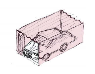
This transformation of the domestic landscape reflects a broader shift where the ‘sanctity of the home’ is redefined by its ability to withstand physical assault rather than its visual or cultural expression.
Voluntary duties of the non-sleeping village
Through the repetitive nature of settler violence, residents have identified a predictable pattern of aggression. These attacks are often rooted in the concept of ‘Price Tag’ or ‘Revenge,’ where settlers, particularly groups like the ‘Hilltop Youth,’ hold Palestinians collectively responsible for any major incident involving Israelis. This occurs even in cases of accidents, external missile fire, or friendly-fire incidents within the Israeli army. Additionally, these aggressive patterns intensify during holidays and religious seasons. Consequently, residents have developed communal habits to prevent and resist these invasions.
The heart of this resistance is the creation of emergency-only social media networks (e.g., WhatsApp groups) to facilitate rapid mobilization. These digital platforms have transformed the village into a ‘non-sleeping’ entity. Residents in homes overlooking hilltops or those in high-risk peripheral locations serve as voluntary sentinels, monitoring for any uncommon movement throughout the night (Figure 17). This system maintains constant vigilance, ensuring that an emergency call or message is promptly responded to, regardless of the time. This prompt response often leads to the arrival of cars from various parts of the village, providing aid to those in need.

Beyond immediate defense, these groups facilitate the flow of critical information, such as road closures, military presence, or community notices. To mitigate the risk of military surveillance, these conversations often utilize ‘self-deleting’ features, a necessary precaution, as soldiers may confiscate and search residents’ phones at any time. This blend of social bonding and modern digital tools represents a form of organized, non-sleeping resistance that safeguards both the physical and social fabric of the village.
Community solidarity and help
Beyond the physical act of night shifts and monitoring, the community’s resilience is sustained through the donation of funds, tools, and spaces. Recognizing that not every individual can participate in night watches, many contribute by financing essential equipment. In response to repeated arson attacks, the community launched a fundraising campaign to buy a water-tank truck to serve as a local fire truck. Additionally, handheld fire extinguishers and high-intensity searchlights for night surveillance were distributed to vulnerable households. This solidarity extends to spatial resources. For instance, since many residents lack private garages to protect their vehicles, local car-wash businesses offer their facilities as free, secure parking spaces during the night. This collective repurposing of private spaces reflects a sophisticated level of communal bonding in a contested landscape. Sumud means remaining, persevering, continuing, and enduring. In Area C, these practices translate into daily acts of resistance, where residents actively maintain their presence and reclaim their lands despite escalating settler attacks.
References
Fanon, F. (1963). The wretched of the earth. Grove Press. https://monoskop.org/images/6/6b/Fanon_Frantz_The_Wretched_of_the_Earth_1963.pdf
Abujidi, N. (2009). The Palestinian states of exception and Agamben. Contemporary Arab Affairs, 2(2), 272–291. https://doi.org/10.1080/17550910902857034
Shalev, N., Cohen-Lifshitz, A., & Mardi, D. (2008). The prohibited zone: Israeli planning policy in the Palestinian villages in Area C. Bimkom.
Hammad, J., & Tribe, R. (2021). Culturally informed resilience in conflict settings: a literature review of Sumud in the occupied Palestinian territories. International Review of Psychiatry, 33(1–2), 132–139. https://doi.org/10.1080/09540261.2020.1741259
Palestinian News and Info Agency (Wafa). (2024, October 15). Musta’maroun yaqta’oun ashjar zaytoon fi Burqa sharq Ramallah [Colonizers cut down olive trees in Burqa, east of Ramallah]. Palestinian News and Info Agency. https://www.wafa.ps/pages/details/105798
Applied Research Institute–Jerusalem [ARIJ] & Land Research Center [LRC]. (2018, August 16). Expanding “Givat Asaf” in Beitin village / Ramallah Governorate. POICA. https://poica.org/2018/08/expanding-givat-asaf-in-beitin-village-ramallah-governorate/
Harvey, D. (2010). Social justice and the city (Rev. ed.). University of Georgia Press.
[1] (Applied Research Institute–Jerusalem [ARIJ] & Land Research Center [LRC], 2018)
[2] (Wafa, https://www.wafa.ps/pages/details/105798)
[3] G.Hamed, interview by author, March 1, 2026.
[4] A. Hamed, interview by author, March 1, 2026.